BARTable by bike: Delta de Anza Trail
Where:
1200 Frederickson Lane
Antioch, CA 94509
United States
BART Station:
Pittsburg/Bay PointThe Delta de Anza Trail connects you to the Black Diamond Mines Regional Preserve and Contra Loma Regional Park in the Delta region. Photo courtesy of BARTable staff.
Difficulty
• Beginner-intermediate
Terrain
• Short route: Mostly flat with some small rolling hills, about 13 miles with 600 feet elevation gain.
• Long route: Follows the short route with the addition of a steep climb into Black Diamond Mines Regional Preserve, about 18 miles with 1,200 feet elevation gain.
Cautions
• The route includes rolling hills. Make sure your gears are in good working order and that your brakes are tuned up for a more pleasant experience.
The Contra Costs Canal runs along the trail. Photo courtesy of BARTable staff.
Introduction
With this ride, we'll explore the rolling hills of East Contra Costa County along the Delta de Anza Regional Trail. Follow the route taken by Spanish explorer Juan Bautista de Anza during his 18th century expedition through the Delta region where the present-day cities of Pittsburg and Antioch are located. Our ride takes you to the serene reservoir of Contra Loma Regional Park, and if your legs are feeling up for it, tackle the steep climb into Black Diamond Mines Regional Preserve to experience even more natural beauty along with the former sites of thriving coal mining towns.
What to bring
Comfortable riding shoes, helmet, water bottles, sun protection (hat, sunscreen), extra layers or rain gear (just in case). A smartphone is handy for maps and looking up information or taking photos. And, of course, your Clipper card. Make sure to download the Ride with GPS app so you can easily reference the route.
How to get there
The ride begins directly outside of the Pittsburg/Bay Point Station. Exit the station, follow the road down to the traffic light at Bailey Road and you'll find the beginning of the trail on the southeastern corner of the intersection next to the Highway 4 on-ramp (don't get on the freeway!).
Short route
Long route
Highlights of the ride
Rolling hills
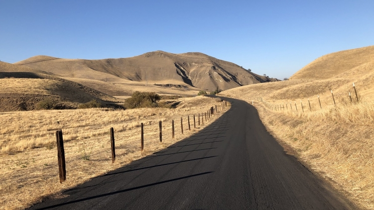
The trail starts out flat and runs along Highway 4, but quickly moves into quieter pastures and the rolling hills begin. Most of the hills on the trail are preceded by a descent, so as long as you keep your momentum up, they're not particularly taxing.
The trail has plenty of twists and turns and ups and downs to keep things interesting. Photo courtesy of BARTable staff.
Contra Loma Regional Park
Contra Loma's 775 acres include a peaceful 80-acre reservoir with many trails surrounding it for year-round bike rides, walks, and hikes. In the summer, the swim lagoon (currently closed as of January 2021) is a popular way to cool off. Additionally, family-friendly music events with food and beverages frequently take place.
Take a snack break near the Contra Loma Reservoir. Photo courtesy of BARTable staff.
Black Diamond Mines Regional Preserve
Originally populated by the Chupcan, Volvon, and Ompin Native Americans, after the arrival of the Spanish, Mexican and American settlers in 1772, life in this area changed rapidly. Cattle ranching was the major industry here until coal was discovered in the mid-1860s. Today, little sign of the past remains.
Venture off the trail for a trip through Black Diamond Mines Regional Preserve. Photo courtesy of BARTable staff.
Somersville Townsite
Within Black Diamond Mines Regional Preserve, at the end of the paved road, is the former site of an active coal mining town called Somersville. At the peak of operations in the 1850s-1900s, Somersville was the largest community in Contra Costa County. By the late 1800s, mines began to close due to increased production costs and competition from higher quality Washington Territory coal. The town of Somersville slowly died. Today, mine waste rock piles, exotic trees planted by the former residents and Rose Hill Cemetery are all that remain.
At the end of the paved road, you'll find the former site of the town of Somersville. Photo courtesy of BARTable staff.
The short route ends a few easy miles from Contra Loma Regional Park at the Antioch Station. The long route adds a climb of about 600 feet elevation gain (the vistas are worth it!) into Black Diamond Mines Regional Preserve, and then continues to follow the short route with a stop at Contra Loma Regional Park and a finish at Antioch Station.
Visit bart.gov/bikes to check BART’s bike rules, then strap on your helmet and get out there!
Let's be bike buddies.
Taking a BARTable by bike ride? Let us know via social media, @SFBARTable #SFBARTable! Keep up with us on Facebook, Instagram and Twitter to see all of the best BARTable (virtual) events, places to eat (grab take out from) and have fun (outside) around the Bay.
