BARTable Walk: Colma to San Bruno
When:
On a nice day
Where:
365 D Street
Colma, CA 94014
United States
BART Station:
ColmaWalk Time:
4.5-5 hoursWoodlawn Memorial Park on El Camino Real in Colma. Photo courtesy of Guy Joaquin.
You’ve heard of a pub crawl, but what about a cemetery crawl? Try one out on this BARTable Walk and visit the graves of some notable figures in Colma, then get up close and personal with the South San Francisco Hillside Sign and top it off with a hearty Basque meal. On egin!
Walk Time: 4.5 – 5 hours | Distance: 8 miles | Terrain: Sidewalks, paved & dirt trails
Route Maps
Sign Hill (Letters Trailhead to Ridge Trailhead)
Sign Hill to San Bruno Station
Before starting the walk, a quick lesson on the history of Colma might be helpful. As is already well known, San Francisco began to grow exponentially with the start of the Gold Rush in 1848. Along with the boom came a corresponding demand for more housing. Sound familiar? One type of real estate that caught the eye of developers was cemeteries. They were seen as taking up valuable space and accused by the public of being sources of health hazards. So in 1901, the city said no more to new burials and went further in 1914 when it ordered all cemeteries to be closed (except the National and Mission Dolores Cemeteries) and for the bodies exhumed and moved out. Where did they go? South to greener pastures in Colma. Up to the 1940s, more than 150,000 bodies are estimated to have been moved to new and relocated cemeteries.
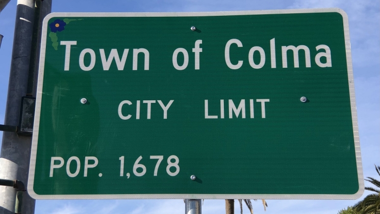 With around 1.5 million graves, the ratio of “below ground” to “above ground” residents is about a thousand to one so it’s fitting that the Town of Colma is known as the “City of Souls.” Photo courtesy of Guy Joaquin.
With that to set the scene, exit the Colma Station through the main entrance and head right to El Camino Real. Take a right and cross F Street to the first of three stops on this tour: Woodlawn Memorial Park. Originally the Masonic Cemetery in San Francisco, it moved to Colma in 1904 and brought along more than 19,000 bodies. Guarding the entrance is its grand Gothic-style chapel said to resemble a medieval castle. Taking about 15 years to complete, it was constructed with white granite from the Sierras.
Perhaps the most famous burial at Woodlawn is of the eccentric Joshua A. Norton, better known as Norton I, Emperor of the United States and Protector of Mexico. Born in England, Norton came to San Francisco during the Gold Rush and made his wealth from commodities trading and real estate speculation. He eventually lost his fortune and turned to making money by, literally, making money (i.e., counterfeiting). Besides conferring upon himself the title of Emperor, his many proclamations included the dissolution of Congress and construction of a bridge from San Francisco to Oakland back in 1872! Norton was a San Francisco fixture, known for wearing a blue military outfit with gold epaulets. He died in 1880 and was first buried in San Francisco before being moved to Woodlawn. Tip: Stop by the cemetery office for directions to the gravesite.
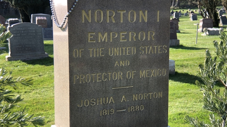 Many groups celebrate Emperor Norton, including the Clampers who gather at his grave in Woodlawn Memorial Park every year on January 8 (anniversary of his death) to eat fresh crab in their black suits and red shirts. Photo courtesy of Guy Joaquin.
Use the crosswalk in front of Woodlawn to the other side of El Camino Real and turn right to continue south. After Serramonte Blvd is the next stop: Cypress Lawn Memorial Park. Head left under the impressive stone archway into its East Campus. Founder Hamden Holmes Noble established Cypress Lawn in 1892 after seeing the dilapidated state of cemeteries in San Francisco. If you think it feels a lot like a garden, you are on to it. Noble set out to create a rural, or garden, cemetery with rolling terrain, wide roads, ponds and trees for a park-like setting for the public to enjoy.
The list of persons interred in the 87 private mausoleums is a Who’s Who of prominent Californians, including sugar industrialist Claus Spreckels, newspaper publisher Charles de Young and Comstock Bonanza King James Flood. Arguably the most impressive is that of the Hearst family where George, Phoebe, son William Randolph and other members are entombed. George built the family fortune from investments in gold, silver and copper mines and used it to buy the San Francisco Examiner in 1880. William later took over the reins and grew it into the multinational, mass media conglomerate Hearst Communications. Meanwhile, Phoebe used the fortune to fund various philanthropy projects, such as providing seed money to start the University of California.
 Phoebe Apperson Hearst commissioned the family mausoleum in Cypress Lawn Memorial Park, which is a reproduction of the Temple of Athena Nike on the Acropolis in Athens. Curiously, the family name does not appear anywhere on it. Photo courtesy of Guy Joaquin.
Head back to El Camino Real and continue south to the left. Don’t miss stopping by Molloy’s Tavern on the other side of the street. This local joint ticks all the boxes for the classic Irish dive bar: dark woods, Victorian chandeliers, Guinness on tap, old-time photos, Irish music on the jukebox and even a countdown to St. Patrick’s Day. Irish immigrant Frank Molloy opened the pub in 1927 during the height of Prohibition with the enterprising idea of providing a place for funeral parties to raise glasses one last time for their departed loved ones. Molloy also owned a few speakeasies in San Francisco and used Colma as a staging area for bootlegging operations.
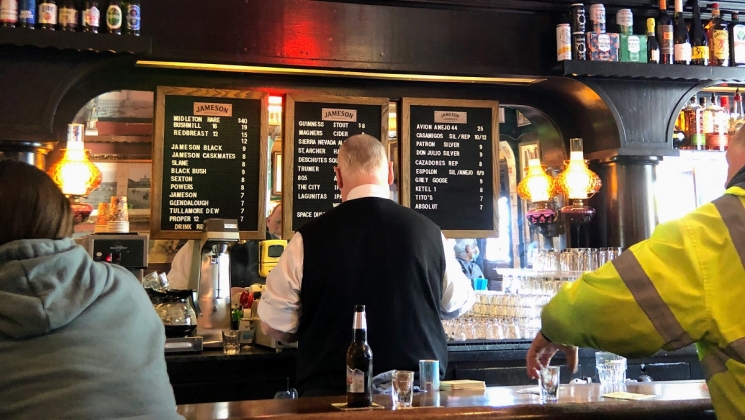 Still family-run, Molloy’s Tavern is located in the historic Old Brooks Hotel built in 1883. In addition to hotel, the building’s previous incarnations include brothel, casino and stagecoach stop. Photo courtesy of Guy Joaquin.
Return to the other side of El Camino Real and head right to the third and final stop: Holy Cross Catholic Cemetery. This one was established in 1887 on 300 acres giving it the distinction of being the oldest and largest cemetery in Colma. The land was part of the Rancho Buri Buri Mexican land grant that encompassed much of the North Peninsula, including what is now South San Francisco and San Bruno. Here is where bodies were reinterred (about 40,000) from the Mt. Calvary Cemetery in San Francisco. Film buffs know that scenes from the 1971 dark comedy cult classic “Harold and Maude” were shot on the grounds.
Holy Cross also has its list of celebrity burials, such as assassinated San Francisco mayor George Moscone, Bank of America founder A.P. Giannini and Italian-born American sculptor Benny Bufano. Baseball fans though journey to pay their respects at the grave of legendary Joe DiMaggio. Born in Martinez and raised in North Beach, this local boy made good backed away from becoming a fisherman like his father to play ball in the big leagues. With the help of older brother Vince, DiMaggio was picked up by the San Francisco Seals in 1932 and made his Major League debut with the New York Yankees in 1936 where he went on to have one of the most storied careers in baseball history. On the field, his most famous achievement is his 56-game hitting streak in 1941. Off the field, it may be his marriage to Golden Age of Hollywood actress Marilyn Monroe. They eloped and were married at San Francisco City Hall in 1954.
 Joe DiMaggio’s funeral was held at Sts. Peter and Paul Church in North Beach on March 11, 1999 and he was buried three months later at Holy Cross Catholic Cemetery. Photo courtesy of Guy Joaquin.
Continue south along El Camino Real, go past the South San Francisco Station and veer left onto Grand Avenue. Take a left onto Eucalyptus Avenue, a right onto Park Way and then a left onto Rocca Avenue. At Poplar Avenue, turn left again up to Sign Hill for a micro-hike (just half a mile or so) along the South San Francisco Hillside Sign. We know it better as the “South-San Francisco-The Industrial City” sign that we see when driving up 101 past the airport into the City. Conceived to attract more industry to the area, the original sign was constructed in 1923 (same year as the Hollywood sign) with letters carved into the hillside and filled with whitewash. Local high schoolers did the upkeep and removed weeds and reapplied the whitewash. The sign was updated with the current four-inch-thick concrete letters in 1929. With the city’s economy moving from heavy industry and manufacturing to high-tech and biotechnology, there were calls to remove or change the sign to “The Industrious City,” but it was saved when awarded with a historic designation in 1996.
 The letters of the South San Francisco Hillside Sign range in height from 48 to 65 feet so that even though they are placed on uneven ground, they appear straight when viewed from a distance (a technique called anamorphosis). Photo courtesy of Guy Joaquin.
Take the Letters Trail to the right that passes directly under the sign. At its end, take a right onto the Ridge Trail and head downhill. Follow the trail to the left of the metal tank out of the park and turn right onto Spruce Avenue. Then turn right onto Grand Avenue and take a left onto Magnolia Avenue all the way to the Basque Cultural Center, a real Bay Area gem hidden among the industrial buildings. Like the cemeteries in Colma, the center traces its origins back to San Francisco, specifically North Beach, where a Basque community began to grow at the start of the Gold Rush. Along with Basque restaurants and boarding houses, community life centered on playing pilota (Basque handball) on Sundays on the back wall of a bowling alley that faced the Helen Wills Playground. When the building was set to be demolished in 1979, members banded together to fund the construction of the center that opened in 1982 with its own handball court. Camino de Santiago pilgrims are delighted to see the center highlight South San Francisco’s sister city relationship with Donibane Garazi (Saint-Jean-Pied-de-Port in French), a traditional starting point on the Camino Francés route in Basque Country.
 The Basque Cultural Center’s restaurant opened to help cover costs then became highly successful in its own right, earning the reputation of offering excellent old country cuisine in large portions and at a great value. It was featured in the local restaurant review series “Check, Please! Bay Area.” Photo courtesy of Guy Joaquin.
Finish the walk by taking a right onto Railroad Avenue and then another right back onto Spruce Avenue. After Myrtle Avenue, cross to the other side of Spruce Avenue and take the Centennial Trail through to the San Bruno Station.
For some retail therapy or to pass the time before the next train, pop into The Shops at Tanforan directly behind the station. Before the shoppers, the area had already seen a long and layered history of human activity from ancestors of the Urebure Ramaytush Ohlone tribe, Spanish colonialists, Mexican ranchers and European settlers. In 1899, the Tanforan Racetrack opened on the site as an outlet for gambling that had been banned in San Francisco. It was named after Toribio Tanforan, grandson-in-law of José Antonio Sánchez who owned Rancho Buri Buri. Then in 1942, the Wartime Civil Control Administration turned the site into the Tanforan Assembly Center where around 8,000 persons of Japanese ancestry from around the Bay Area were detained after the signing of Executive Order 9066. They were housed in converted horse stables, the grandstand and temporary barracks while waiting to be transferred to permanent, so-called “War Relocation Centers” in other parts of the West and Southwest. Conditions were harsh with poor sanitation and hunger, not to mention the loss of freedom and privacy.
 After 50+ years of standing, The Shops at Tanforan is scheduled to be torn down to make way for housing and a huge, one million square foot business campus. Photo courtesy of Guy Joaquin.
Route Maps
Sign Hill (Letters Trailhead to Ridge Trailhead)
Sign Hill to San Bruno Station
Variations and options
-
Customize the walk: Plan your own route to visit other cemetery sites of interest, such as the memorial to American Airlines flight attendant on 9/11 Betty Ong at Cypress Lawn’s Hillside Gardens or the Levi Strauss mausoleum at the Home of Peace Cemetery. The KQED Bay Curious article “Some of the Most Famous People Buried in Colma (With Map)” lists more notable burials with an interactive map. Also recommended is the joyous and colorful Pet’s Rest Cemetery.
-
Join a tour: Cypress Lawn offers docent-led trolley tours of all three campuses. Holy Cross provides a walking tour brochure of famous gravesites at the reception desk in the main office.
-
Split the walk: Spend more time exploring the cemeteries and finish at the South San Francisco Station. Pick it back up another time and include a leisurely lunch or dinner at the Basque Cultural Center.
What to bring: Sturdy walking shoes and a daypack with water, bag lunch or snacks (or pick up along the way), sun protection (hat, sunscreen), extra layers or rain gear (just in case). A smartphone is handy for maps and looking up info or taking photos. And, of course, your Clipper Card or App!
About the stations
Colma Station opened in February of 1996. The station sits in an open-cut valley shared with its parking structure and the Daly City Maintenance Yard. It served as a terminal station until the opening of the remaining stations of the BART system expansion to SFO and Millbrae in June 2003. The station was featured in the 2006 independent film “Colma: The Musical.”
San Bruno Station opened in June of 2003. Built on land acquired from the adjacent Tanforan shopping center, it was part of the BART system expansion to SFO and Millbrae. A memorial to the Tanforan Assembly Center outside the station is scheduled for completion in 2022. Inside, photographs from photojournalists Dorothea Lange and Paul Kitagaki, Jr. portraying the internment of Japanese Americans during World War II are on permanent display.
We're social.
What's your favorite part of this walk? Let us know via social media, @SFBARTable #SFBARTable! Keep up with us on Facebook, Instagram and Twitter to see all of the best BARTable events, places to eat and have fun around the Bay.
