BARTable Walk: Downtown Berkeley to El Cerrito Plaza
When:
On a nice day
Where:
2160 Shattuck Ave
Berkeley, CA 94704
United States
BART Station:
Downtown BerkeleyWalk Time:
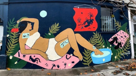
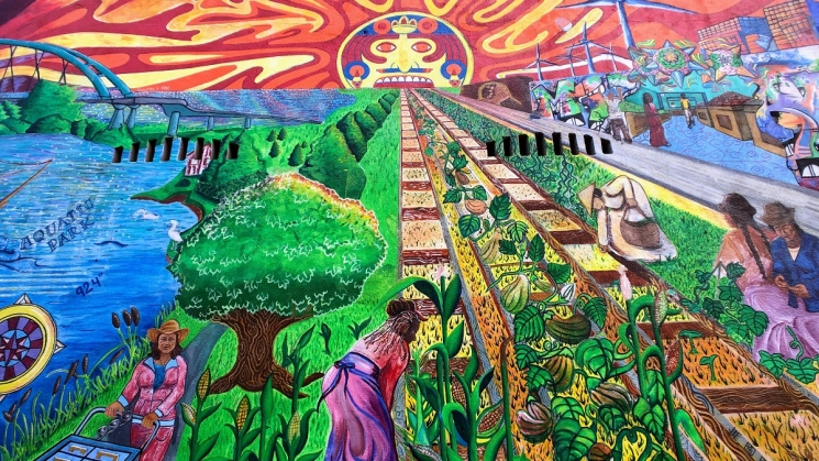
4.5-5 hoursThe mural “Vivir Sin Fronteras/Living Without Borders” outside Mi Tierra Foods on San Pablo Avenue in Berkeley. Photo courtesy of Guy Joaquin.
Come celebrate the Bay and learn how it was saved from being paved over, explore an outdoor gallery of urban art and visit the park better known as “doggie heaven” on this BARTable Walk along the San Francisco Bay Trail through Berkeley and Albany to Richmond.
Walk Time: 4.5 – 5 hours | Distance: 9.5 miles | Terrain: Sidewalks, paved & dirt trails
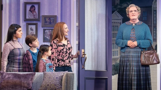
Exit the Downtown Berkeley Station using Exit B1 up to Addison Street and head left to start the walk from the Downtown Berkeley Arts District. Home to several live theaters, like the Berkeley Repertory and Aurora Theatres, as well as the California Jazz Conservancy music school, this special district is a regional hub for arts and entertainment. For live music, Freight & Salvage is the long-standing go-to spot. Since 1968, this local institution has been a beacon for a diverse range of Americana, traditional and global music acts, such as Eric and Suzy Thompson, Judy Collins and Dennis Kamakahi to name a few. The “Freight” got its name from a sign at its original location on San Pablo Avenue that was an old used-furniture store. Its Open Mic night is the longest-running open stage event in the Bay Area and has welcomed performances from musician Shawn Colvin and comedian Dana Carvey.
 Freight & Salvage’s current location is a former city garage (you can still see “Stadium Garage” stamped above the marquee) that features a 490-seat capacity and sound system from Meyer Sound of Berkeley. Photo courtesy of Guy Joaquin.
As you continue down the street, get some literary inspiration from The Addison Street Poetry Walk, a series of 120+ cast iron plates in the sidewalk with poems picked by U.S. Poet Laureate and Cal professor Robert Hass. Further down at West Street, you can duck into the aptly named The Hidden Café, hidden just inside Strawberry Creek Park to grab a coffee, tea or pastry while enjoying the works of local artists. Take the Lehua Way alley that connects the west and east ends of Addison and carry on towards the Bay through the West Berkeley neighborhood.
Just before the railroad tracks at Fourth Street is Takara Sake USA. You surely have seen their sake at your local sushi joint, but did you know that it’s brewed in Berkeley? Responding to growing interest in Japanese foods and culture, particularly after the Shogun TV miniseries aired in 1980, Takara began brewing operations here in 1983 using Calrose rice and water from the Sierras. Two renovations and expansions later, they now brew a wide variety of sake from junmai to nigori to nama styles. Though their sake museum and tasting room are currently closed, they run virtual tastings where you are guided through a selection of sake delivered to your home.
 In 1983, Takara Sake USA released its first American-made sake, now called "Sho Chiku Bai Classic Junmai Sake” with its gold label that was redesigned in 2002. Photo courtesy of Guy Joaquin.
At the end of Addison Street, go around Aquatic Park to the right and use the Berkeley I-80 pedestrian bridge to cross over the freeway and head left (north) to join the San Francisco Bay Trail. With over 350+ miles already completed, this planned 500-mile path circles the entire Bay passing through nine Bay Area counties and 47 cities and crossing seven bridges.
At University Avenue, check out the catch of the day at Seabreeze Market & Deli. This roadside landmark, still family-run, started serving up classic seafood shack fare in 1981 out of a food truck before moving into more “permanent” shipping container digs. Hikers, runners, bikers and drivers all tuck into their fish and chips, crab sandwiches and clam chowder on picnic tables out front. Especially on sunny, warm days, it’s the perfect spot to pitstop and watch the world go by.
 During the season, get to Seabreeze Market & Deli early to order sweet Dungeness crab, steamed and served in-shell with garlic butter. Photo courtesy of Guy Joaquin.
Cross to the other side of University Avenue and veer left to McLaughlin Eastshore State Park. This parkland covers 1,833 acres and stretches 8.5 miles along the shoreline from the Bay Bridge to Richmond. Today, Bay Area residents and visitors appreciate the magnificent treasure that is the Bay and its shoreline. However, before the 1960s, there was a very different mindset. The Bay was a dumping ground for city trash and raw sewage and being infilled for real estate development. Berkeley resident Sylvia McLaughlin witnessed this from her hillside home and decided that enough was enough. In 1961, she banded together with fellow residents Kay Kerr and Esther Gulick to form the Save San Francisco Bay Association, now known as Save The Bay. The trio, along with thousands of other residents, blocked a plan to double the size of Berkeley by filling in 2,000 acres of the Bay. They went on to support efforts to stop similar initiatives elsewhere and thereby helped reverse the trajectory of the Bay. Narrated by Robert Redford, the four-part docuseries "Saving the Bay" includes the efforts of McLaughlin and her cohort.
 We shudder to think what the Bay would be today without the visionary leadership of Sylvia McLaughlin, Kay Kerr, Esther Gulick and the Save The Bay organization. Photo courtesy of Guy Joaquin.
Head into the park through the gate to the Berkeley Meadow and take the trail that leads to the right. As you pass jackrabbits hiding under coyote brush and listen to bees and other pollinators buzzing from flower to flower, let it sink in that you are standing on top of 12 feet of garbage! This was one of the city dumpsites, like those Sylvia McLaughlin saw from her home that spurred her to action. Restoration work on the meadow entailed hauling away toxic waste and concrete debris, creating wetland areas to attract migratory birds and replacing non-native and invasive plants with native shrubs and grasses.
Exit the meadow and continue straight (north) past the Tom Bates Regional Sports Complex. At the Golden Gate Fields horse racing track is one of the newest and perhaps most intricately engineered extensions of the Bay Trail to date. From Bay level, the trail gently rises to 45 feet on a paved path that hugs the side of a bluff and crosses a 180-foot long bridge before dropping back down to the shoreline. Not only does it offer spectacular views of San Francisco, the Golden Gate Bridge and Mount Tam, but it also provides a peaceful break from the traffic noise. The multi-million dollar project, two decades in the making, took two years to complete and included shoreline and beach restoration; a staging area with parking, restrooms and picnic tables; as well as new and improved trails.
 Though just a mile long, the Albany Beach and SF Bay Trail Project completed in 2020 was a major achievement and critical linchpin to connect Richmond and Oakland. Photo courtesy of Guy Joaquin.
At the Albany Beach restrooms, hang a left and head out to the Albany Bulb. Like the Berkeley Meadow, the “Bulb” got its start as a dumpsite created from construction debris infilling from 1961 to 1984. By the 1990s, it had become the dominion of hikers, dog walkers, birdwatchers and urban explorers. During the same period, a community of “Bulb-dwellers” formed who made their homes among the debris and the trees and shrubs that had taken root. In 1999, Albany cleared the residents, around 60 by then. Some returned and the community grew back to about 40 by 2013 when the city voted to evict and all were cleared out again by 2014. The documentary "Bum’s Paradise" chronicles the lives of residents around the time of the 1999 eviction. Fast forward to today, a lasting legacy of the community and others it attracted is the fantastical urban art made of concrete and rebar debris as well as driftwood and other found materials. In the short documentary "Off-Leash Art," two artists provide history and commentary on the Bulb and the art. Though much has disappeared or deteriorated since its peak in the mid- 2000s, there is still plenty to marvel at, including sculptures, graffiti, stencils and even a labyrinth. One of the famous works is the concrete Mad Mark's Castle, named after its builder, a former resident.
 The “Beseeching Woman,” a metal and wood sculpture by lawyer and local activist Osha Neumann and son-in-law Jason DeAntonis, greets visitors to the Albany Bulb. Photo courtesy of Guy Joaquin.
After touring the Bulb, double back down the trail, but continue straight along Buchanan Street towards the East Bay Hills. At the freeway underpass, head to the left (north again) and follow the trail all the way around the Albany Mudflats. At Central Avenue, continue to the left and just where it meets the Point Isabel Wet Weather Treatment Plant, head off the trail down to TEPCO Beach, a real hidden gem of the Bay. Strewn across this small stretch of shoreline, about the length of a football field, are thousands of broken pieces of ceramic dishes from the old Technical Porcelain and Chinaware Company (TEPCO) founded by Italian immigrant John Pagliero in 1918. The company manufactured dinnerware at their factory in El Cerrito from 1930 up until their closure in 1968 that was supplied to local restaurants, like Spenger’s Fish Grotto and Trader Vic’s, and to the U.S. Army and Navy during World War II. TEPCO used the beach to dispose of broken and defective dishes back when, again, the Bay was commonly used as a dumping ground. Today, their ceramics are considered collector’s items.
 At TEPCO Beach, it’s your lucky day if you find a piece of ceramics with the TEPCO label, but be sure to “catch and release” so that others can have the chance, too! Photo courtesy of Guy Joaquin.
Climb back up to the trail and continue around to Point Isabel Regional Shoreline. This 23- acre park started out as a much smaller, natural promontory named for the daughter of Don Victor Castro who owned the land, part of the Mexican land grant Rancho San Pablo, and used it to ferry goods and supplies across the Bay during the 1800s. The point grew to its current size by, you guessed it, infilling – with dirt and debris from its original hilltop that was dynamited in the 1950s to make way for development. But the park is not nearly as well-known for its human history as for its canine visitors. Dogs are allowed off-leash (if under voice control) to freely run amok chasing tennis balls and each other. Within the park, Mudpuppy's Tub & Scrub offers dog bathing services and supplies while the adjacent Sit & Stay Café sells yummy treats for both dogs and their human companions. Add in the sweeping views of the Bay and it’s no surprise that, according to the park website, “well over one million visitors come to the park each year, most of them with their dogs.”
 It’s reported that Point Isabel Regional Shoreline once made #1 on an annual list of best dog parks by the People for the Ethical Treatment of Animals (PETA). Photo courtesy of Guy Joaquin.
Make a lap around the parking lot (or explore further into the park) and then exit down Isabel Street. Take a left onto Central Avenue and keep straight for about 1.5 miles to finish the walk at the El Cerrito Plaza Station.
Variations and options
- Extend the walk: Make it a loop and continue with BARTable Walk: El Cerrito Plaza to Downtown Berkeley. Go even further and explore the Berkeley campus and beyond with BARTable Walk: Downtown Berkeley to Rockridge.
- Add a side trip: From the Seabreeze market, take a detour down University Avenue and around the Berkeley Marina and César Chávez Park (add 2 hours, or 4.5 miles).
- Walk the route in reverse: Start from the El Cerrito Plaza Station and catch a movie or show, shop or grab a bite to eat in Downtown Berkeley.
What to bring: Sturdy walking shoes and a daypack with water, bag lunch or snacks (or pick up along the way), sun protection (hat, sunscreen), extra layers or rain gear (just in case). A smartphone is handy for maps and looking up info or taking photos. And, of course, your Clipper Card or App!
About the stations
Downtown Berkeley Station opened in January of 1973. It is one of three stations in Berkeley (others being Ashby and North Berkeley). Located just one block from the University of California, a significant number of passengers are students, faculty and staff. A redevelopment of the main entrance and plaza was completed in 2018 that included the replacement of the original metal rotunda entrance with a glass canopy structure.
El Cerrito Plaza Station opened in January of 1973 and is named after the nearby El Cerrito Plaza shopping center. Like its twin, El Cerrito del Norte, it is an elevated station that sits along the Ohlone Greenway pedestrian and bicycle path. The staircase and escalator walls to the platform feature mosaic murals by Mexican-born American artist Alfonso Pardiñas. A transit- oriented community is planned for development on the station’s parking lots.
We're social.
What's your favorite part of this walk? Let us know via social media, @SFBARTable #SFBARTable! Keep up with us on Facebook, Instagram and Twitter to see all of the best BARTable events, places to eat and have fun around the Bay.

